

This article is about old maps of Wycombe and what they tell us about the town. Kindly prepared by Alan Powers of High Wycombe Library, it will be of particular interest to those readers who are interested in family and local history.
The maps referred to are shown below.
Maps have many uses. Street maps can help you find your way around town. Road maps can show the route from one town to another. Ramblers use footpath maps to plan out a day’s walk.
The UK’s main mapping agency is the Ordnance Survey. The familiar Landranger series of maps covers the whole country from Land’s End to John O’Groats and all places in between.
More specialised maps can be used to see boundaries, rainfall patterns, or the types of soil beneath our feet.
Maps also have a long history. The oldest surviving map in the UK dates from the 11th century, while the earliest map of any part of Buckinghamshire in the County Archives in Aylesbury is a plan of the Boarstall Estate, dating from c.1444.
Earliest Maps of High Wycombe

The first map of the county, showing the location of the town (as “Highe Wickhm”) was printed in 1574, when Queen Elizabeth I was on the throne.
The earliest street of High Wycombe Map 1 (see facing page) is over 200 years old, printed in 1822, although a possibly earlier map was reproduced in the book The Early History and Antiquities of High Wycombe by John Parker, published in 1878. It shows the town at an (unspecified) early date and depicts a settlement a far cry from today, with just the High Street forming the spine of the town, and a handful of other roads branching off it.
Frogmore is shown, next to “Le Green”, while Castle Street is here called All Hallows Lane. Buildings familiar to us today include the church, the Guildhall and four pubs along the High Street – the George, the Red Lion, the Antelope and the Three Tuns.
(A comment I should have added to my earlier email concerns the 1822 map on the first page, where I state that four familiar pubs are shown on the map – the George, the Red Lion, the Antelope and the Three Tuns. I know that the Antelope and the Three Tuns are still going strong, but I am not so sure about the George or the Red Lion. Maybe that line needs some correcting!)
Other older maps can show how the town has grown over the years. Map 2 (see facing page) digitised by the National Library of Scotland shows the town at the end of the nineteenth century, with virtually the whole town limited to either side of the main London Road.
Large Scale Maps
Large-scale maps from the past can also locate buildings or even roads that no longer exist. By way of example, the 1911 census lists a number of households in Laura Place, High Wycombe. Anyone tracing their family history and looking for the house where their ancestor may have lived would be hard pressed to find Laura Place today, either on a street map or on the ground. If, however, you go back in time to an older map Map 3 (see facing page), you will find Laura Place situated just north of Lily’s Walk, and so is now buried under the Eden Centre.
Large-scale maps like these can also help you get some idea when the road you live in was developed and even when your house was built. You are not likely to get the exact year from a map, as they were only published at long intervals, but at least it will narrow down the period.
The development of Micklefield is an example, Map 4 (see facing page), again digitised by the National Library of Scotland, shows the first stages of work in creating the Micklefied area we know today.
The different style of blocking in of housing on the map shows that Micklefield Road, Hicks Farm Rise and Herbert Road creeping up the hillside, while most of the rest of the area remains as unspoilt countryside at that time. Meanwhile, a little to the west, the Bowerdean Road and Totteridge Road areas are also in the process of being built up.
Experian Goad Maps
Ordnance Survey are not the only company producing maps today. A completely separate series of maps is published by a company called Experian Goad, and show town centre shops and companies in great detail. These maps were started at the end of the nineteenth century, when insurance companies were estimating the fire risks of individual buildings and needed to know the precise location in the town of each building, and whether buildings on either side made insurance a risky proposition. If, for example, the owner of a particular building wanted to insure it against fire or other damage, but had, let’s say, a dynamite factory next door, the insurance company would certainly want to know. However, if the insurance company were based miles away in somewhere like Manchester, they would find it difficult to survey buildings in High Wycombe.
Enter Charles Goad, who drew up detailed plans of town centres all over the country to sell to the insurance companies. Over time the plans have become important historical documents, as they show shops that have long since ceased trading.
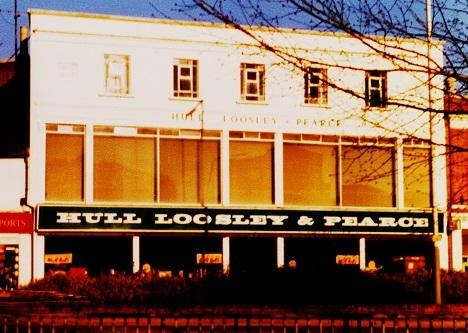
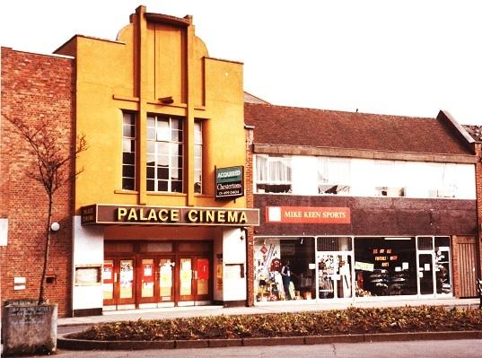
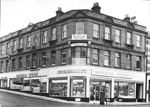
Goad maps for High Wycombe feature many long-lost names. Do you remember the Imperial Stores from the 1960s; Hull, Loosley & Pearce Department Store, Budgens Supermarket or Parslows Bakery from the 1970s; Byrds Wine Bar, Mike Keen Sports or Visionhire from the 1980s; or C&A, Tandy Electronics or the Gas Showrooms from the 1990s; and where in the town they were located? The Goad maps show all these, and many other long-departed stores.
Experian Goad maps operate a strict copyright, so none of the plans can be reproduced here, but half an hour’s looking through them in the library can bring back many memories.
The full range of Ordnance Survey Landranger and Explorer maps can be borrowed from the library. In addition reference copies of both series are held, along with many older maps. The series of High Wycombe town centre maps published by Experian Goad from 1974 can also be viewed in the library.


Comments: Our rules
We want our comments to be a lively and valuable part of our community - a place where readers can debate and engage with the most important local issues. The ability to comment on our stories is a privilege, not a right, however, and that privilege may be withdrawn if it is abused or misused.
Please report any comments that break our rules.
Read the rules hereLast Updated:
Report this comment Cancel